Global Compute Map
3,670 sites
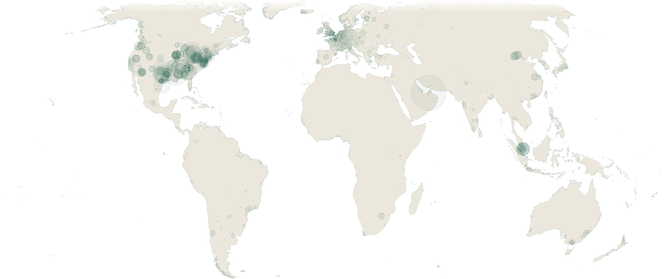
Sites in view
3,670 sites, largest first.
| Facility | Country | Company | Stage | Power, MW | Operating, MW |
|---|---|---|---|---|---|
| Stargate UAE (OpenAI/G42/Oracle)Oracle Corporation | United Arab Emirates | Oracle Corporation | Under construction | ~5,000 | |
| AWS Project Rainier (New Carlisle, IN)Amazon.com, Inc. | United States | Amazon.com, Inc. | Operational | ~2,200 | ~1,244 |
| Meta Richland Parish (Hyperion)Meta Platforms, Inc. | United States | Meta Platforms, Inc. | Under construction | ~2,000 | |
| Oracle Vantage Data Centers FrontierOracle Corporation | United States | Oracle Corporation | Announced | ~1,400 | |
| Colossus 2xAI | United States | xAI | Operational | ~1,276 | ~1,276 |
| Stargate Abilene (OpenAI/Oracle/SoftBank) | United States | Operational | ~1,200 | ~865 | |
| Beacon Point Data Center | United States | Under construction | 1,000 | ||
| Crusoe Goodnight in Claude, TexasCrusoe | United States | Crusoe | Announced | ~1,000 |
 United
 United
Related pages
Sources
7 sources
- Epoch AI Frontier Data Centers: https://epoch.ai/data/data-centers
- IM3 / PNNL data-center corpus: https://www.openstreetmap.org/copyright
- PeeringDB facility registry: https://www.peeringdb.com/
- GridStatus: https://www.gridstatus.io/
- Operator filings and disclosures (SEC EDGAR, 20-F, press): https://www.sec.gov/edgar/search/
- Publishable facility corpus: https://scrutica.com/methodology#data-sources
- Natural Earth (land, coast and borders): https://www.naturalearthdata.com/
Research cited
- Bobby Xiong, Davide Fioriti, Fabian Neumann, Iegor Riepin, Tom Brown, Prebuilt Electricity Network for PyPSA-Eur based on OpenStreetMap Data, Zenodo, 13 Nov 2024 (ODbL v1.0)
How the figures were made
Sites. Records are drawn from the publishable facility corpus (4,304 rows), which excludes licensed-vendor rows by definition (94 rows withheld); 72 duplicate records of a campus are counted once, leaving 4,232 sites. Of those, 3,670 render as marks, one per site; 561 have no coordinates, and the map’s filters (duplicate pins on one campus; bare OpenStreetMap records above 70° north) exclude 1. The methodology sets out how a facility enters the corpus.
The world. Equal Earth on the Greenwich meridian, an equal-area projection, so every region keeps its true share of the plate. The whole-world view runs from 74° north to 56° south. Land and coast are Natural Earth 1:10m; past about three times, the plate adds the countries its records sit in and pale land borders from Natural Earth 1:50m, which draws de facto boundaries.
Circles. A circle’s area is proportional to the site’s power, and it keeps its size at every zoom, so sizes compare across views; at the whole-world view it is the size the site’s own record draws. A pale circle is a figure not counted as operating capacity (announced, permitted or under construction; expanding with no operating share recorded; retired; or a build-out figure with no operating plant recorded inside it). Where a record states more power than it operates, a forest circle for the operating figure sits inside the pale one.
Dots. A dot is a site with no power figure, pale where its record is not counted as operating capacity. At the whole-world view, dots that would overlap settle round their recorded position and stay on land, so density builds into dark clusters; a dot can sit up to about 450 km from its record (median about 100 km). Zooming in returns dots to their records. A site with a circle never moves.
Heat. A Gaussian density of the drawn sites on the equal-area plane, with a standard deviation of about 241 km. The lines stand at 0.5, 2 and 8 sites per 10,000 km².
EU grid substations. The layer’s substations come from PyPSA-Eur’s prebuilt network, version 0.6, derived from OpenStreetMap.